
Famous landmarks in Bangladesh
3 landmarks
Bangladesh on My Earth Toy, the free 3D toy globe for kids: 3 landmarks. Here you can see its flag, capital and size, then fly to every place on the globe.
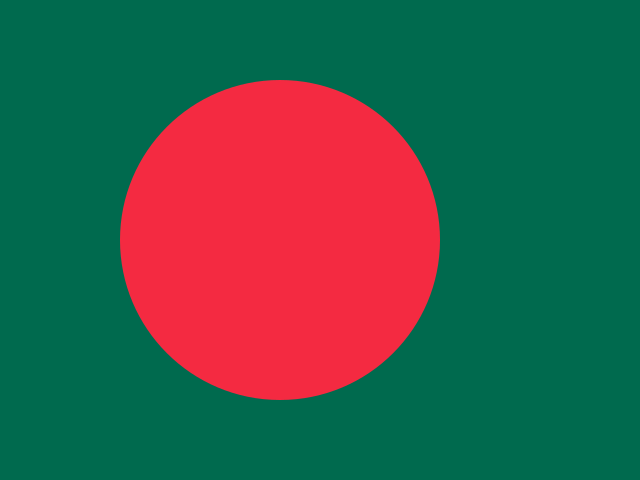
The flag of Bangladesh is dark green with a large red circle, placed a little toward the flagpole side.
Read about this flag →Bangladesh at a glance
- Capital
- Dhaka
- Continent
- Asia
- Area
- 148,460 km²
- Population
- 173.6 million
Bangladesh is a country in South Asia, on the Bay of Bengal, almost completely surrounded by India, with a short border with Myanmar. Its capital is Dhaka, one of the most crowded cities in the world, and about 174 million people live in the country, making it one of the most densely populated nations on Earth. Bangladesh is known for its great rivers, green rice fields, the Sundarbans mangrove forest and the Bengal tiger.
On My Earth Toy you can visit three landmarks in Dhaka: Jatiya Sangsad Bhaban, the striking concrete parliament building surrounded by water; Ahsan Manzil, the pink palace by the river; and Lalbagh Fort, an unfinished Mughal fort with the tomb of Pari Bibi.
Geography and nature
Most of Bangladesh is a huge, flat delta formed where the Ganges, Brahmaputra and Meghna rivers meet the sea. Hundreds of rivers cross the land, and the soil is very fertile. Monsoon rains fall in summer and floods are common. In the southwest lies the Sundarbans, the largest mangrove forest in the world, shared with India and home to Bengal tigers. Hills rise only in the southeast, near Chittagong.
People, languages and culture
Nearly everyone speaks Bengali, or Bangla. Most people are Muslim, and there are also Hindu, Buddhist and Christian communities. Rice and fish are at the centre of meals, and the hilsa is the national fish. Colourful cycle rickshaws fill the streets of Dhaka. The poet Rabindranath Tagore wrote the national anthem. Cricket is the most popular sport, and Pohela Boishakh, the Bengali New Year, is celebrated with music, fairs and parades.
History in a nutshell
The region of Bengal has been home to kingdoms and empires for over two thousand years, including the Mughal Empire, which built Lalbagh Fort. It later came under British rule. In 1947 British India was divided, and this area became East Pakistan. In 1952 students protested to have Bengali recognised as a state language. After a war in 1971, Bangladesh became an independent country.
Fun facts
- International Mother Language Day on 21 February honours the 1952 protests for the Bengali language.
- Cox's Bazar has one of the longest natural sea beaches in the world, roughly 120 kilometres long.
- The Sundarbans tigers are known for swimming between islands in the mangrove forest.
- The parliament building was designed by the American architect Louis Kahn.
Famous landmarks in Bangladesh
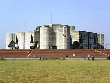
Jatiya Sangsad Bhaban
Bangladesh · Asia
Bangladesh’s parliament house, Louis Kahn’s monumental concrete citadel inlaid with white marble bands: giant triangles, circles and arches are cut into its walls, and it rises from an artificial lake that wraps around it.
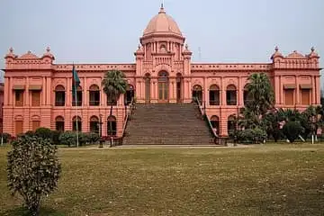
Ahsan Manzil
Bangladesh · Asia
The 'Pink Palace' of the Nawabs of Dhaka on the Buriganga river, built 1859–1872 in Indo-Saracenic style and now a museum.
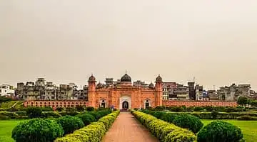
Lalbagh Fort (Tomb of Pari Bibi)
Bangladesh · Asia
Unfinished Mughal fort in Old Dhaka, begun in 1678 by Prince Muhammad Azam and continued by Shaista Khan.
Questions
What is the capital of Bangladesh?
The capital of Bangladesh is Dhaka.
Which continent is Bangladesh in?
Bangladesh is in Asia.
How big is Bangladesh?
Bangladesh covers about 148,460 km².
How many people live in Bangladesh?
About 173.6 million people live in Bangladesh.
What are the most famous landmarks in Bangladesh?
Some of the best-known landmarks in Bangladesh are Jatiya Sangsad Bhaban, Ahsan Manzil and Lalbagh Fort (Tomb of Pari Bibi). My Earth Toy has 3 landmarks from Bangladesh on its free 3D globe, each with a photo and quick facts.
Sources
Updated: 2026-10-30