
Togo: landmarks, animals & facts for kids
1 landmark
Togo on My Earth Toy, the free 3D toy globe for kids: 1 landmark. Here you can see its flag, capital and size, then fly to every place on the globe.
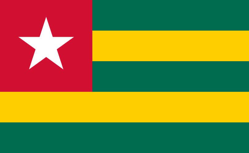
Five horizontal stripes, green and yellow in turn, with a red square in the top left corner holding a white five-pointed star.
Read about this flag →Togo at a glance
- Capital
- Lomé
- Continent
- Africa
- Area
- 56,785 km²
- Population
- 9.5 million
Togo is a small country in West Africa on the Gulf of Guinea. It is long and narrow: only about 50 kilometres of coastline, but it stretches more than 500 kilometres inland. It borders Ghana to the west, Benin to the east and Burkina Faso to the north. The capital, Lomé, lies on the coast right next to the border with Ghana.
Togo is known for its palm-lined beaches, hilly forests, busy markets and the mud tower-houses of the Batammariba people. On the globe you can find the Independence Monument in Lomé, a tall white monument built to celebrate the day Togo became a free country in 1960.
Geography and nature
Togo's coast is a strip of sandy beaches and lagoons, including Lake Togo. Behind it is a plateau, and then the Togo Mountains, part of the Atakora range, cross the country from south-west to north-east; Mont Agou, about 986 metres, is the highest point. The centre and south have forests and plantations of cocoa and coffee, while the north is dry savanna. Hippos, monkeys and many birds live in parks such as Fazao-Malfakassa. Togo is also known for mining phosphate, used to make fertiliser.
People, languages and culture
French is the official language, while Ewe in the south and Kabiyè in the north are national languages, and about 40 languages are spoken in all. Many Togolese are Christian, others are Muslim, and traditional beliefs, including Vodun, remain important. Lomé's Grand Market is famous for its women cloth traders. In the north-east, the Batammariba people build takienta, two-storey mud houses with towers and granaries, in the Koutammakou landscape. Favourite foods include fufu, pounded yam, and akoumé, a maize dough served with sauces.
History in a nutshell
Ewe, Kabiyè and other peoples settled the region over centuries. From the 1500s European ships traded along the coast, part of what was called the Slave Coast. In 1884 Germany made Togoland a protectorate. After the First World War it was split between Britain and France; the British part later joined Ghana. French Togo became independent on 27 April 1960, a day still celebrated each year. Togo's Independence Monument in Lomé honours that moment.
Fun facts
- Koutammakou, the land of the Batammariba and their tower-houses, is a UNESCO World Heritage Site.
- Togo's coastline is only about 50 kilometres long, one of the shortest in Africa.
- Lomé's Akodessewa market sells traditional medicines and charms used in Vodun ceremonies.
- Togo's flag has five green and yellow stripes and a white star on a red square.
Famous landmarks in Togo
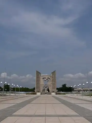
Independence Monument, Lomé
Togo · Africa
Sculptor Paul Ahyi's monument to Togo's 1960 independence, where a woman raising her arms stands in the curved opening between two tall pierced pylons.
Questions
What is the capital of Togo?
The capital of Togo is Lomé.
Which continent is Togo in?
Togo is in Africa.
How big is Togo?
Togo covers about 56,785 km².
How many people live in Togo?
About 9.5 million people live in Togo.
What are the most famous landmarks in Togo?
On My Earth Toy's free 3D globe, the landmark from Togo is Independence Monument, Lomé, with a photo and quick facts.
Sources
Updated: 2026-10-30