
Micronesia: landmarks, animals & facts for kids
1 landmark
Micronesia on My Earth Toy, the free 3D toy globe for kids: 1 landmark. Here you can see its flag, capital and size, then fly to every place on the globe.
Micronesia at a glance
- Capital
- Palikir
- Continent
- Oceania
- Area
- 702 km²
- Population
- 0.1 million
The Federated States of Micronesia is an island country in the western Pacific Ocean, north of New Guinea. It is made up of 607 islands spread across about 2,700 kilometres of ocean, grouped into four states: Yap, Chuuk, Pohnpei and Kosrae. Its capital is Palikir, on the island of Pohnpei. The country is known for coral reefs and lagoons, rainy green islands, giant stone money and ancient ruins.
On My Earth Toy you can explore Nan Madol, a ruined city of nearly 100 artificial islets built from stacked basalt columns in a lagoon off Pohnpei. It is a UNESCO World Heritage Site and is sometimes called the Venice of the Pacific.
Geography and nature
Micronesia has two kinds of islands: high volcanic islands such as Pohnpei and Kosrae, covered in rainforest, and low coral atolls barely above the waves. The highest point, Nanlaud on Pohnpei, is 782 metres tall. Pohnpei's mountains are among the rainiest places on Earth, feeding many waterfalls. Chuuk Lagoon is one of the largest lagoons in the world, and its coral reefs are home to sharks, turtles, manta rays and colourful fish. Typhoons sometimes hit the islands.
People, languages and culture
English is the official language, and each state has its own local languages, including Chuukese, Pohnpeian, Yapese and Kosraean. Most people are Christian. Families are very important, and traditional chiefs are still respected in many communities. On Yap, huge stone discs called rai, some taller than a person, were traditionally used as money and are still displayed in villages. Traditional navigators in the outer islands are famous for crossing the ocean by reading stars, waves and winds.
History in a nutshell
People reached these islands by canoe thousands of years ago. On Pohnpei, the Saudeleur dynasty ruled from Nan Madol for centuries before it fell around the early 17th century. Spain claimed the islands in the 19th century, then sold them to Germany in 1899. Japan took control in 1914, and after the Second World War the United States governed them for the United Nations. Micronesia became a self-governing country in 1986, in free association with the United States.
Fun facts
- Yap's stone money discs can be up to about 3 metres wide, and ownership could change without the stone ever moving.
- Chuuk Lagoon's seafloor holds dozens of sunken Second World War ships, now covered in coral.
- Nobody knows for certain how the builders of Nan Madol moved its enormous basalt columns.
- Pohnpei's mountains get so much rain that they are counted among the wettest places on Earth.
Famous landmarks in Micronesia
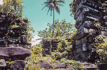
Nan Madol
Micronesia · Oceania
The ceremonial and royal-burial city of the Saudeleur dynasty: nearly 100 artificial islets off Pohnpei walled with criss-crossed basalt columns, the "Venice of the Pacific".
Questions
What is the capital of Micronesia?
The capital of Micronesia is Palikir.
Which continent is Micronesia in?
Micronesia is in Oceania.
How big is Micronesia?
Micronesia covers about 702 km².
How many people live in Micronesia?
About 0.1 million people live in Micronesia.
What are the most famous landmarks in Micronesia?
On My Earth Toy's free 3D globe, the landmark from Micronesia is Nan Madol, with a photo and quick facts.
Sources
- Federated States of Micronesia — Wikipedia
- The World Factbook (CIA), Micronesia, Federated States of — factbook.json archive
Updated: 2026-10-30