
Aoraki / Mount Cook National Park
아오라키/마운트쿡 국립공원
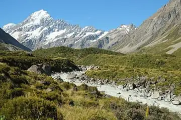
South Island park around Aoraki / Mount Cook (3,724 m), New Zealand's highest mountain; the Hooker Valley Track leads over swing bridges to a glacier lake with floating icebergs.
See it on the 3D globe →At a glance
- Country
- New Zealand
- Type
- Park
Quick answers
Where is Aoraki / Mount Cook National Park?
Aoraki / Mount Cook National Park is in New Zealand.
Aoraki / Mount Cook National Park is in the middle of the South Island of New Zealand, in the Canterbury region and the Southern Alps. It was set up in October 1953 and covers about 707 square kilometres. It is named for Aoraki / Mount Cook, 3,724 metres high, the tallest mountain in New Zealand. It shares a border with Westland Tai Poutini National Park along the Main Divide.
Glaciers cover about 40 percent of the park, including Haupapa / Tasman Glacier, the country's largest. In 1990 the park became part of the Te Wāhipounamu World Heritage Site. Today the Department of Conservation looks after it together with Ngāi Tahu, the Māori tribe who are the traditional guardians of the land. Some of its land was first protected as early as 1885.
How the valleys were carved
About 13,000 years ago, at the end of the last ice age, many glaciers in the park joined a giant glacier that filled the Hooker and Tasman valleys under hundreds of metres of ice. It reached 40 kilometres past today's Lake Pukaki. When it melted away, it left the wide U-shaped valleys you see in the park today.
A mountain with two names
In Māori legend, Aoraki was a son of Raki, the Sky Father. He and his brothers came down in a canoe, but it overturned. They climbed onto it and turned into mountains: Aoraki, Rakiroa, Rakirua and Rārakiroa. The canoe became the Southern Alps.
In 1851 Captain Stokes of the survey ship HMS Acheron named the mountain Mount Cook to honour James Cook. A law passed in 1998 recognised the original Māori names too, so places now have dual English and Māori names.
Life, stars and visiting
The park has more than 400 plant species and about 35 kinds of birds, including the rare black stilt and the pīwauwau (rock wren). The only road in is State Highway 80, which starts about 65 kilometres away near Twizel and ends at Mount Cook Village.
The Hooker Valley Track is the most popular walk, taking about three hours. The skies are very dark here, and in 2012 the park and the Mackenzie Basin became the Aoraki Mackenzie International Dark Sky Reserve.
Fun facts
- Aoraki/Mount Cook, 3,724 m tall, is New Zealand's highest mountain.
- Glaciers cover roughly 40 percent of this park.
- In one Māori legend the mountains are brothers who climbed on to an overturned canoe.
- The park is part of an International Dark Sky Reserve created in 2012.
- Aoraki is the Māori name; Mount Cook honours Captain James Cook.
On the globe
The model shows the snowy peak of Aoraki / Mount Cook with glaciers beneath it, in the New Zealand Alps.
Nearby on the globe


Sources
- Read more on Wikipedia
- Aoraki / Mount Cook National Park — English Wikipedia
- 아오라키 마운트쿡 국립공원 — 한국어 위키백과
Updated: 2026-10-14