
Southern lights (Stewart Island)
남극광 (스튜어트섬)
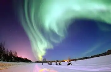
New Zealand's southernmost inhabited island is a favourite place to see the aurora australis; its Māori name, Rakiura, is often translated as 'land of glowing skies'. The giant chain sculpture at Lee Bay recalls the Māori story of the island as the anchor stone of Māui's canoe.
See it on the 3D globe →At a glance
- Country
- New Zealand
Quick answers
Where is Southern lights (Stewart Island)?
Southern lights (Stewart Island) is in New Zealand.
The southern lights, or aurora australis, are a natural light show in the sky made when charged particles from the Sun hit oxygen and nitrogen high in Earth's atmosphere. The gases glow green, red and purple, in curtains, rays and spirals. The southern lights look almost the same as the northern lights and change at the same time as them.
The globe marks them over Stewart Island, called Rakiura in Māori, the third-largest island of New Zealand. It lies about 30 kilometres south of the South Island across Foveaux Strait and covers roughly 1,700 square kilometres. The southern lights can be seen from Antarctica, Patagonia, southeastern Australia, New Zealand and the Falkland Islands, and in a big magnetic storm they can reach even farther north.
Why these lights glow
The Sun sends out a stream of particles called the solar wind. When it speeds up, it shakes Earth's magnetic bubble, and electrons and protons pour down toward the poles.
They strike thin air far above the ground, usually around 100 kilometres up, and each gas gives off its own color. Auroras gather in a ring around each pole called the auroral oval, which is why places near Antarctica see them most often.
Stewart Island, land of glowing skies
The island's Māori name, Rakiura, is usually translated as 'glowing skies', a reference to the aurora australis. Another old name, Te Punga o Te Waka a Māui, means 'the anchor stone of Māui's canoe', from a legend in which Māui fished up the North Island.
Archaeology shows people settled here in the 14th century. Captain James Cook sailed around it in 1770 but drew it as a peninsula of the South Island, and the island was later proved by sailors to be separate. Its English name honors William Stewart, first officer of the ship Pegasus.
A wild, quiet island
Stewart Island is hilly and thickly forested, with its highest point, Mount Anglem, rising to 980 metres. More than 80 percent of it is Rakiura National Park, and almost all of the land belongs to the New Zealand government.
Only about 486 people live here, mostly in the village of Oban, which ferries connect to Bluff. Nearby Ulva Island is a sanctuary kept free of introduced pests, and Codfish Island protects the kākāpō, a rare parrot.
Fun facts
- Stewart Island's Māori name, Rakiura, is often translated as 'land of glowing skies', fitting for a place where the southern lights appear.
- Rakiura, the island's Māori name, is usually translated as 'glowing skies'.
- Captain Cook sailed around the island in 1770 but marked it as part of the South Island on his chart.
- About 18,000 years ago sea levels were around 100 metres lower, and Stewart Island was joined to the rest of New Zealand.
- Both poles have auroras: aurora borealis in the north and aurora australis in the south.
On the globe
The model shows green curtains of the southern lights over the island of southern New Zealand.
Nearby on the globe


Sources
Updated: 2026-10-14