
Tajikistan: landmarks, animals & facts for kids
1 landmark · 1 animal
Tajikistan on My Earth Toy, the free 3D toy globe for kids: 1 landmark, 1 animal. Here you can see its flag, capital and size, then fly to every place on the globe.
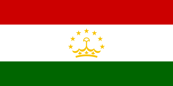
Three horizontal stripes of red, white and green, with a wider white stripe in the middle holding a gold crown under an arch of seven gold stars.
Read about this flag →Tajikistan at a glance
- Capital
- Dushanbe
- Continent
- Asia
- Area
- 143,100 km²
- Population
- 10.6 million
Tajikistan is a landlocked country in Central Asia. It borders Afghanistan, China, Kyrgyzstan and Uzbekistan. More than 90 per cent of the country is covered by mountains, and much of it lies over 3,000 metres above sea level. The capital is Dushanbe, whose name means 'Monday' because a market was once held there on that day.
Tajikistan is known for the Pamir Mountains, often called the 'Roof of the World', for glaciers, turquoise lakes and its place on the old Silk Road. On the globe you can find the Dushanbe Flagpole, one of the tallest flagpoles in the world, and the Marco Polo sheep, a wild sheep with enormous curling horns.
Geography and nature
The Pamirs fill the east of Tajikistan, and Ismoil Somoni Peak, about 7,495 metres, is the highest point. The Fedchenko Glacier, about 77 kilometres long, is one of the longest glaciers outside the polar regions. Lake Sarez formed in 1911 when an earthquake caused a landslide that blocked a river. Fast rivers such as the Vakhsh and Panj rush through deep valleys, and the Nurek Dam on the Vakhsh is one of the tallest dams in the world. Snow leopards, ibex and Marco Polo sheep live high in the mountains.
People, languages and culture
Tajik, a form of Persian written in the Cyrillic alphabet, is the official language, and Russian is widely used. People in the Pamirs speak their own languages too. Most Tajiks are Muslim. Families gather in teahouses called chaikhanas, and the national dish is qurutob, bread soaked in a salty yoghurt sauce and topped with vegetables; plov, a rice dish, is also loved. Navruz, the spring new year, is a big celebration, and the medieval poet Rudaki is honoured as a father of Persian poetry.
History in a nutshell
In ancient times this region was part of Sogdia and Bactria, and Silk Road caravans passed through cities such as Panjakent. In the 800s and 900s the Samanid Empire, led by Ismoil Somoni, made the region a centre of Persian culture. Later it was ruled by Turkic, Mongol and Uzbek states, and in the 1800s by the Russian Empire. In 1929 it became a Soviet republic, and it gained independence on 9 September 1991. A civil war followed from 1992 to 1997, and peace has held since.
Fun facts
- The Dushanbe Flagpole is about 165 metres tall and was the tallest flagpole in the world when it was finished in 2011.
- Tajikistan's highest peak used to be called Communism Peak before it was renamed Ismoil Somoni Peak.
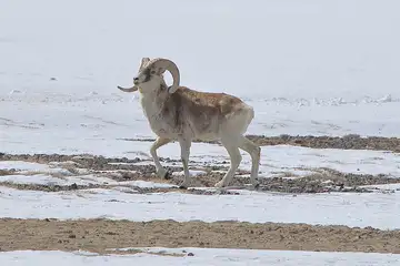
- Marco Polo sheep are named after the explorer Marco Polo, who described them on his journey across the Pamirs.
- The Usoi landslide dam that holds back Lake Sarez is the tallest natural dam in the world.
Famous landmarks in Tajikistan
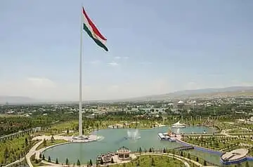
Dushanbe Flagpole
Tajikistan · Asia
At 165 m, the Dushanbe Flagpole was the tallest flagpole in the world when it was finished in 2011.
Animals in Tajikistan
Questions
What is the capital of Tajikistan?
The capital of Tajikistan is Dushanbe.
Which continent is Tajikistan in?
Tajikistan is in Asia.
How big is Tajikistan?
Tajikistan covers about 143,100 km².
How many people live in Tajikistan?
About 10.6 million people live in Tajikistan.
What are the most famous landmarks in Tajikistan?
On My Earth Toy's free 3D globe, the landmark from Tajikistan is Dushanbe Flagpole, with a photo and quick facts.
Which animals can you find in Tajikistan on My Earth Toy?
On the globe you can find Marco Polo sheep in Tajikistan.
Sources
Updated: 2026-10-30