
Bouvet Island
부베섬
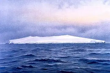
The most remote island on Earth, about 1,700 km from Antarctica and 2,260 km from the nearest inhabited place, Tristan da Cunha. A Norwegian nature reserve 93% covered by glacier; visits need permission from Norway.
See it on the 3D globe →At a glance
- Country
- Bouvet Island
- Kind
- Off-limits places
Quick answers
Where is Bouvet Island?
Bouvet Island is in Bouvet Island.
Bouvet Island is an uninhabited volcanic island in the South Atlantic Ocean, at the southern end of the Mid-Atlantic Ridge. It belongs to Norway and is protected as a nature reserve. It is called the most remote island in the world: the nearest land is Antarctica's Queen Maud Land, 1,700 kilometres to the south, and the nearest coast of South Africa is about 2,520 kilometres away.
The island covers just 49 square kilometres, and 93 percent of that is covered by a glacier. Its center is the ice-filled crater of a volcano that is not active. The highest point, Olavtoppen, rises 780 metres. The climate is cold, foggy and cloudy, with an average of about minus 1 degree Celsius. The globe marks it as a remote island in the middle of the cold ocean.
Lost and found again
French captain Jean-Baptiste Charles Bouvet de Lozier spotted the island through fog on 1 January 1739, while searching for a great southern continent. He could not land and recorded the position wrongly, so later ships failed to find it for decades. It was seen again in 1808 by the British whaler James Lindsay.
In 1898 the German Valdivia expedition fixed its position accurately. A second island, 'Thompson Island', appeared on maps until 1943, but nobody has found it since, and the sea there is more than 2,400 metres deep.
Becoming Norwegian
The first Norvegia expedition landed in 1927, raised the Norwegian flag and claimed the island, and a royal decree confirmed this in January 1928. Britain had an older claim from 1825 but gave it up in November 1929, partly because of confusion over which island the earlier landing was on.
Norway made it a dependency in 1930. In 1971 the whole island and its waters became a nature reserve. The third Norvegia expedition in 1929 took aerial photographs, the first Antarctic expedition to use aircraft.
Ice, rock and a mystery lifeboat
Most of the coast is steep ice cliffs and there is no natural harbour. Nyrøysa, a field of rocks without ice, formed between 1955 and 1958, probably in a landslide. It is the largest ice-free area on the island.
In 1964 a British survey team found an empty lifeboat there that no one could identify. It was recovered in 1978 and believed to belong to a Soviet research ship. During the same visit, scientists measured an underground temperature of 25 degrees Celsius.
Fun facts
- Mostly covered by glaciers, it is the most remote island on Earth; the nearest land, Antarctica, is about 1,700 km away.
- Bouvet is called the most remote island in the world.
- The Valdivia expedition of 1898 was the first to fix the island's position accurately.
- A phantom 'Thompson Island' stayed on maps until 1943, though the ocean there is over 2,400 metres deep.
- An abandoned lifeboat found on the island in 1964 was identified only years later as probably Soviet.
On the globe
The model shows an ice-covered volcanic island with dark rock, alone in the South Atlantic.
Nearby on the globe

Sources
Updated: 2026-10-14