
Sahara (largest hot desert)
사하라 사막 (가장 큰 더운 사막)
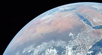
The largest hot desert on Earth, about 9.2 million km² — nearly the size of China or the United States. Sand seas like the Murzuq here cover only about a quarter of it; the rest is rocky plateau and gravel plain.
See it on the 3D globe →At a glance
- Country
- Libya
Quick answers
Where is Sahara (largest hot desert)?
Sahara (largest hot desert) is in Libya.
The Sahara is the largest hot desert in the world. It covers about 9.2 million square kilometres of North Africa, nearly as much land as the whole United States, and stretches from the Atlantic Ocean in the west to the Red Sea in the east, and from the Mediterranean coast and the Atlas Mountains in the north to the Sahel, a belt of dry grassland, in the south. Its name comes from the Arabic word for "desert".
Parts of about ten countries lie in the Sahara, including Algeria, Chad, Egypt, Libya, Mali, Mauritania, Niger and Sudan. Only the icy deserts of Antarctica and the Arctic are bigger. The Sahara matters because it shapes the weather and history of a whole continent, and because it has not always been a desert: thousands of years ago much of it was green.
Not just sand
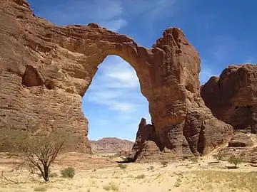
Many people picture the Sahara as endless sand dunes, but sand seas, called ergs, make up only part of it. Much of the desert is hamada, bare rocky plateaus, and reg, wide plains of gravel. There are also dry river valleys called wadis, salt flats, oases where water reaches the surface, and tall volcanic mountains such as the Tibesti and Ahaggar ranges. The highest point is Emi Koussi, a volcano in northern Chad. Some sand dunes rise more than 180 metres.
The hottest large region on Earth
Clouds rarely form over the Sahara, so the sun shines for more than 3,600 hours a year in most places. Summer days in some spots average well over 40 °C, and the sand itself can heat up to 80 °C. Because the dry air does not hold heat, nights are often 13 to 20 °C cooler than days. Rain is very rare: in the eastern Sahara an area of about a million square kilometres gets almost no rain at all, and some places go years without a single shower.
When the Sahara was green
For hundreds of thousands of years, the Sahara has switched back and forth between desert and grassy savanna. Slow wobbles in the tilt of the Earth's axis move the African monsoon rains north and south over cycles of about 20,000 years. Between roughly 8000 and 6000 BCE, rains returned, lakes filled and animals and people spread across the land. Lake Chad is what is left of a huge ancient lake. People from that time left paintings and carvings on the rocks that can still be seen. By about 3400 BCE the Sahara had become as dry as it is today.
Fun facts
- At about 9.2 million km², the Sahara is nearly as big as the United States.
- The Sahara is so large and bright that, in theory, it could be spotted from other stars as a feature of Earth using technology close to what we have today.
- The addax, a large white antelope, can go almost a whole year without drinking water.
- Dromedary camels are the favourite animal of Saharan nomads because they are tough and fast.
- Thousands of years ago the Sahara was a green land with lakes and grasslands.
- Some Saharan sand dunes are more than 180 metres tall.
On the globe
On the globe the Sahara spreads across the top of Africa as the wide sandy-coloured land between the Mediterranean and the green Sahel. Zoom in on North Africa to explore it.
Nearby on the globe

Sources
Updated: 2026-10-13