
Mt. Paektu (Baekdu) & Heaven Lake
백두산 (천지)
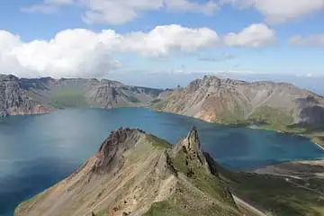
Mount Paektu, called Baekdusan in Korean and Changbai Mountain in Chinese, is a volcano on the border between North Korea and China. At 2,744 metres it is the highest mountain on the Korean Peninsula and in Northeast China. Its top was blown away long ago, leaving a huge bowl-shaped hollow called a caldera, about 5 kilometres wide. That bowl is filled by Heaven Lake, Cheonji in Korean, one of the highest and largest crater lakes in Northeast Asia.
See it on the 3D globe →At a glance
- Country
- North Korea
- Location
- North Korea–China border
- Height
- 2,744 m
- Type
- Volcano
Quick answers
Where is Mt. Paektu (Baekdu) & Heaven Lake?
Mt. Paektu (Baekdu) & Heaven Lake is in North Korea–China border.
The Korean Peninsula's highest volcano (2,744 m), holding Heaven Lake in its summit caldera.
The mountain matters deeply to Korean, Chinese and Manchu people. Old Korean stories link it to the birth of the first Korean kingdom, and it is mentioned in the national anthems of both North and South Korea. The name Baekdu means "white-headed mountain", because its peaks are covered in snow for about eight months of the year and dotted with pale pumice stone.
The Millennium Eruption
Around the year 946, Paektu exploded in what scientists call the Millennium Eruption, one of the most powerful volcanic eruptions on Earth in the last 5,000 years. It blasted out roughly 100 cubic kilometres of rock and ash, destroying the mountain's summit and creating the caldera. Ash from the eruption has been found in Hokkaido, Japan, and even in the ice of faraway Greenland. Historical records from Japan describe "white ash rain" falling on the city of Nara that year. The volcano is still active: its last small eruption was in 1903.
Heaven Lake
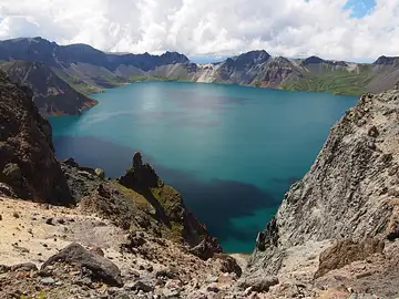
Heaven Lake sits about 2,190 metres above sea level and has a shoreline about 14 kilometres around. It is very deep for a mountain lake, more than 370 metres at its deepest point, which makes it the deepest lake in China. It is usually frozen from mid-October to mid-May. Sixteen peaks over 2,500 metres stand around its rim. Water spills out through a gap in the north side and tumbles down a waterfall about 68 metres high, feeding the Songhua River. Two other big rivers, the Yalu and the Tumen, also begin on the mountain.
Who does it belong to?
Treaties signed by China and North Korea in 1962 and 1964 drew the border straight across the mountain, so the highest peak, Janggun Peak, is in North Korea and about 54.5 percent of Heaven Lake belongs to North Korea, with the rest in China. Today most visitors climb the gentler Chinese side, where a large area around the volcano was named a UNESCO Global Geopark in 2024. Scientists keep a close eye on the mountain because it is thought to erupt about once every hundred years.
Fun facts
- Its 'Millennium Eruption' around 946 AD was one of the most powerful eruptions in recorded history.
- A few months after the great eruption, in early 947, people in Kyoto, Japan, about 1,000 kilometres away, recorded hearing loud explosions.
- Heaven Lake holds nearly 2 billion cubic metres of water.
- For years there were reports of a mysterious creature in Heaven Lake, but scientists doubt that any large animal could live in its cold water.
- The ground at the centre of the mountain has been rising by about 3 millimetres a year, pushed up by magma below.
On the globe
The model shows the snowy volcano with Heaven Lake filling the caldera at its summit, on the border of North Korea and China. Zoom in to look down into the crater and see the lake ringed by peaks.
Nearby on the globe


.jpg)
Sources
- Read more on Wikipedia
- Paektu Mountain — Wikipedia
- 백두산 — 위키백과
- Heaven Lake: China's deepest lake sits atop a colossal volcano — Live Science
Updated: 2026-10-13