
Waitangi Treaty Grounds
와이탕이 조약 기념지
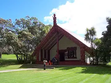
Where the Treaty of Waitangi was signed by the British Crown and Māori chiefs on 6 February 1840, with the 1834 Treaty House, the carved meeting house Te Whare Rūnanga (1940) and the flagstaff marking the signing site.
See it on the 3D globe →At a glance
- Country
- New Zealand
- Location
- Waitangi, Bay of Islands, New Zealand
- Built
- 1840
Quick answers
Where is Waitangi Treaty Grounds?
Waitangi Treaty Grounds is in Waitangi, Bay of Islands, New Zealand.
When was Waitangi Treaty Grounds built?
Waitangi Treaty Grounds was built in 1840.
Waitangi is a small locality in the Bay of Islands, on the North Island of New Zealand, about 60 km north of Whangarei. It is best known as the place where two documents that shaped New Zealand were signed: the Declaration of Independence of New Zealand on 28 October 1835, and the Treaty of Waitangi on 6 February 1840. Its Māori name means 'noisy waters' or 'weeping waters', probably after the nearby Haruru Falls.
The Treaty of Waitangi was an agreement between representatives of the British Crown and Māori chiefs. It was first signed in a large tent put up on the grounds of the house of James Busby, the British resident, and was then taken around the country for more chiefs to sign. Not all chiefs signed; some delayed or refused. Today the Treaty Grounds are open to visitors, and the treaty is still talked about as a founding document of the country.
The signing in 1840
The treaty talks began on 5 February 1840, when Lieutenant Governor William Hobson read a proposal to about 300 Māori and Europeans in front of Busby's house. Many chiefs spoke against giving up power to the Crown at first, while others, including Tāmati Wāka Nene and his brother Eruera Maihi Patuone from Hokianga, spoke in support. The meeting was meant to continue on 7 February, but several chiefs wanted to sign sooner, so the signing took place on 6 February. The treaty followed an earlier document, He Whakaputanga, the Declaration of Independence, and did not cancel it.
What you can see on the Treaty Grounds
The grounds have been open to the public since 1934. The Treaty House, first home of James Busby and his wife Agnes, was restored in the 1930s for the country's centenary in 1940. Close by stands Te Whare Rūnanga, a carved Māori meeting house finished in 1939 and opened on 6 February 1940. It is not a true marae but a carved meeting house. Two museums have opened since: Te Kōngahu Museum of Waitangi in 2016 and Te Rau Aroha Museum of the Price of Citizenship in 2020.
A quiet place today
Waitangi is a rural settlement of about 17 square kilometres and had a population of 57 at the 2023 census, which makes it tiny compared with its fame. It lies right next to the town of Paihia and is joined to it by a bridge near the river mouth. A real marae, Te Tii Waitangi, sits across the river in Te Tī Bay. The Waitangi Wharf at the estuary is used by passenger ferries running between Russell and Paihia.
Fun facts
- About 300 people attended the first public meeting in 1840.
- The name Waitangi means 'noisy waters'.
- Only about 57 people lived in Waitangi at the 2023 census.
- A big war canoe on the grounds needs at least 76 paddlers.
On the globe
The model shows the Treaty House, the carved meeting house and the flagstaff. Look for the flagstaff marking the signing site.
Quiz time
Which is older: Waitangi Treaty Grounds or Ha'amonga 'a Maui Trilithon?
Show the answer
Ha'amonga 'a Maui Trilithon. (1840 vs 1200) Ha'amonga 'a Maui Trilithon →
Nearby on the globe

Sources
Updated: 2026-10-14