
Cotopaxi
코토팍시 화산
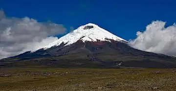
Cotopaxi is a tall, snow-capped volcano in the Andes mountains of Ecuador, about 50 kilometers south of the capital, Quito. At 5,897 meters it is the second-highest peak in Ecuador, and it is one of the highest active volcanoes in the world. Its almost perfectly cone-shaped body rises from a highland plain and is easy to spot from Quito on a clear day.
See it on the 3D globe →At a glance
- Country
- Ecuador
- Location
- Ecuador
- Height
- 5,897 m
- Type
- Volcano
Quick answers
Where is Cotopaxi?
Cotopaxi is in Ecuador.
A snow-capped, symmetrical stratovolcano and one of the highest active volcanoes in the world.
Even though it sits close to the equator, its top is wrapped in a glacier that starts at about 5,000 meters. Its crater is about 800 by 550 meters across and 250 meters deep. The mountain has erupted 87 times that we know of, and an eruption began again in October 2022. It is part of the Pacific Ring of Fire, the great belt of volcanoes around the Pacific Ocean.
What does the name mean?
Local Quechua speakers say the name comes from words meaning "neck" and "moon", which describes the crescent-shaped crater. Andean peoples honored the mountain as sacred long before the Inca arrived. They saw it as a sender of rain that kept the fields fertile and as a home of the gods.
Eruptions and danger
Cotopaxi's biggest eruptions in recorded history came in 1742, 1744, 1768 and 1877. In 1877 hot ash and gas flows melted its whole ice cap, and mudflows called lahars rushed more than 100 kilometers toward the Pacific Ocean and the Amazon basin. The eruptions of 1744 and 1768 destroyed the town of Latacunga. Because lahars can race down river valleys, the government watches the volcano closely, and many people live in its danger zone.
Climbing the volcano
The explorer Alexander von Humboldt tried to climb it in 1802 but only got to about 4,500 meters. The first summit was reached on 28 November 1872 by the German geologist Wilhelm Reiss and his Colombian partner Angel Escobar. Today it is a popular climb. A track goes up to a car park at 4,600 meters, and a mountain hut called the José Ribas Refuge sits a short hike above it. Climbers need crampons and ice axes, because the snow slopes can be as steep as 50 degrees.
Fun facts
- Although it lies close to the equator, its summit is covered by a glacier.
- Cotopaxi has one of the few glaciers in the world that sits right on the equator.
- Its first recorded eruption was in 1534.
- In 1877 an eruption melted its entire ice cap in a single event.
- In the late 1950s NASA built a satellite tracking station here, which later followed Apollo missions.
On the globe
The model shows a symmetrical snow-capped cone; look for the white peak rising high above the Andes.
Nearby on the globe



Sources
Updated: 2026-10-14