
El Peñón de Guatapé
엘 페뇰 데 과타페
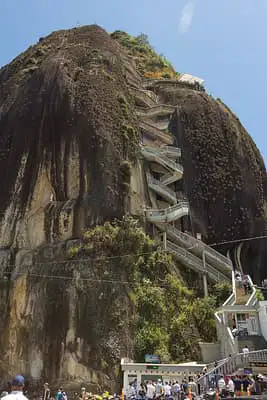
The Rock of Guatapé, called El Peñón de Guatapé or La Piedra, is a huge granite rock that rises from the countryside in Antioquia, Colombia. It is an inselberg, a word for a lone rocky hill that stands above flat land, and it towers up to about 200 meters over its base.
See it on the 3D globe →At a glance
- Country
- Colombia
- Location
- Antioquia, Colombia
- Height
- 200 m
Quick answers
Where is El Peñón de Guatapé?
El Peñón de Guatapé is in Antioquia, Colombia.
How tall is El Peñón de Guatapé?
El Peñón de Guatapé is about 200 m tall.
A giant granite monolith climbed by 708 steps, with panoramic views over a maze of lakes.
People climb a long staircase built into a crack on one side, with about 700 steps, to reach a viewing platform at the top. From the summit you can look out over a maze of lakes and green islands, near the town of Guatapé. The rock is a remnant of hard granite that held out while the softer ground around it wore away, probably because it has fewer cracks than the rock nearby.
What is the rock made of?
It is part of the Antioquia Batholith, a huge body of granite that cooled underground. Geologists say it is about 65 million years old. The rock is mostly quartz, feldspar and granite, and it is roughly 285 metres long and 110 metres wide. It has resisted erosion because it is less fractured than the stone around it.
Who first climbed it?
The Tahamí people, who lived here long ago, worshiped the rock and called it mojarrá, which means rock or stone. It was first officially climbed on 16 July 1954 by Luis Eduardo Villegas López, Pedro Nel Ramírez and Ramón Díaz, who spent five days hammering sticks into the wall. Villegas later bought the rock from local farmers, who thought the land useless, built stairs into the crack and began charging visitors. A statue of him stands at the bottom.
Visiting today
Near the base there are food and market stalls, and about halfway up the stairs is a small shrine. On top are a three-storey viewing tower, a shop and a seating area. Yellow numbers on the steps help count the climb. Helicopter tours circle the rock. Beside the town, the lakes seen from the top were created by a hydroelectric dam.
The towns of Guatapé and El Peñol both claimed the rock. People from Guatapé once began painting the town's name in big white letters on its west face, but a crowd from El Peñol stopped them, leaving a big G and a single stroke of the next letter.
Fun facts
- The stairway up the rock has about 700 steps; Wikipedia counts 708.
- The rock stands up to about 200 meters above its base.
- Its Tahamí-language name is Mojarrá.
- The towns of Guatapé and El Peñol once argued over who owns it, and an unfinished white G is still on its side.
On the globe
The model shows a giant monolith of gray granite with a zigzag stair on its side; look for the lone tall rock.
Quiz time
Which is taller: El Peñón de Guatapé or Christ the Redeemer?
Show the answer
El Peñón de Guatapé. (200 m vs 30 m) Christ the Redeemer →
Nearby on the globe


_2017-04-10.jpg)
Sources
Updated: 2026-10-14