
Lunar Reconnaissance Orbiter
LRO 정찰 궤도선
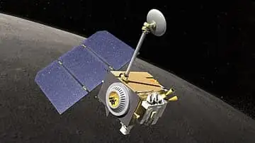
NASA’s mapping orbiter, circling the Moon since 2009. It has photographed the Apollo landers and even their rover tracks, and the Moon map you are looking at right now was made from its pictures.
See it on the 3D Moon →At a glance
- Where
- Polar lunar orbit · since 2009
- 📅 Launched
- 2009-06-18
- 🚀 Sent by
- NASA (USA)
- 📷 Camera
- LROC: sees details down to 50 cm
- Kind
- Spacecraft in orbit
The Lunar Reconnaissance Orbiter, or LRO, is a NASA spacecraft that has been circling the Moon and mapping it since 2009. It launched on 18 June 2009 on an Atlas V rocket from Cape Canaveral, Florida, together with a smaller probe called LCROSS. It was the first American mission to the Moon in more than ten years.
LRO flies on a polar orbit, crossing over both poles, so the whole Moon slowly turns beneath it. Its job is to measure the Moon's surface, temperature, minerals and radiation, help choose safe landing sites, and find places near the south pole with water ice and long hours of sunlight. NASA calls it the longest-lived lunar orbiting mission ever. Its pictures have been used to build detailed maps of the Moon, including the one used for this 3D Moon.
How it works
LRO carries seven instruments. Its camera system, LROC, has narrow-angle cameras that can pick out details about half a metre across from about 50 km up, plus a wide-angle camera. LOLA fires laser pulses at the ground and times their return to measure the height of hills and craters. Diviner measures how hot or cold the surface is, LAMP looks into shadowed craters with ultraviolet light, LEND counts neutrons to hunt for buried ice, CRaTER studies radiation, and Mini-RF is a small radar.
Seeing the Apollo sites
In 2011 NASA briefly lowered LRO's orbit to about 21 km above the surface to take its sharpest pictures. From there LROC photographed the Apollo landing sites, showing the lander bases, science equipment and even the winding trails of astronauts' bootprints. At the Apollo 17 site the double tracks of the lunar rover can be told apart from the footpaths, including the last path humans walked on the Moon in 1972.
Discoveries
LRO has helped build a 3D map covering more than 98 percent of the Moon. It found more than 3,000 small cliffs called lobate scarps, which suggest the Moon is slowly shrinking as its inside cools. It located the crash site of India's Vikram lander in 2019, confirmed where Japan's SLIM lander touched down in 2024, and helped confirm an underground cave in the Sea of Tranquillity.
Fun facts
- LRO's cameras are sharp enough to see the trails of footprints left by Apollo astronauts more than 40 years earlier.
- LRO has found thousands of small cliffs that suggest the Moon is shrinking very slowly.
- NASA calls LRO the longest-lived spacecraft ever to orbit the Moon.
- LRO data helped confirm a cave under the Moon's surface, about 45 m wide and at least 80 m long.
On the 3D Moon
On the 3D Moon you can see LRO circling low over the poles on its mapping orbit. The Moon map you are looking at was made from its pictures.
More on the Moon




Sources
- Read more on Wikipedia
- Lunar Reconnaissance Orbiter — Wikipedia
- Lunar Reconnaissance Orbiter (LRO) — NASA Science
- NASA Spacecraft Images Offer Sharper Views of Apollo Landing Sites — NASA
Updated: 2026-10-19